Most people are celebrating the new year at the moment. Someone is celebrating their birthday as well. Happy Birthday to my MUCH older sister! Have fun Lies.
Oh yes, Happy New Year to everyone else…
Most people are celebrating the new year at the moment. Someone is celebrating their birthday as well. Happy Birthday to my MUCH older sister! Have fun Lies.
Oh yes, Happy New Year to everyone else…
A long time ago, I became intrigued by the idea of having location tag information appended to my images. It wasn’t something that I considered to be vital but it did seem to be potentially useful. However, as I am a Canon shooter, I quickly discovered that this was not going to be something that I could easily achieve. There were a number of GPS devices that you could attach to the hot shoe of a camera and plug in to the USB port but they worked on Nikons while the Canons did not interface with them.
I was a touch disappointed but not so much that it changed my life. I gave up on geotagging for a while until Lightroom 4 came along. It has a useful map module that allows you to see where images were taken if they have coordinates associated with them and so search for shots in a given area. More importantly for me, it allowed you to drag and drop images onto the map to embed the data if they didn’t originally have it. This became part of my workflow.
It did get me more interested in the idea of having real time data with the images rather than trying to decide which shots were taken where. The easiest option appeared to be getting a GPS tracking app for my phone to try. I took a look at the apps available. There are many of them, most of which seemed to be focused on keeping track of members of your family! All rather creepy. All I wanted was something that would keep a track of my location without draining the battery too much.
I settled on an app called GPX Master. It seemed to do what I wanted and had some good reviews. There is a free version with ads embedded or a paid version without ads. Since I was planning on it running in the background, having ads I would rarely see seemed useful. Moreover, it would automatically sync any track files I create with my Dropbox account. I have now taken it out for its first run. The results are very positive.
I was out shooting in a location but I did move a few times. When I got home, I imported my images to Lightroom and turned to the map module. I had checked that the clocks on the cameras were accurate since the time code of the GPS is what makes the process work. The GPX format file was already on my computer courtesy of Dropbox so I was ready to go. At the bottom of the screen was the drop down to select the track file. This I did and a blue track was immediately overlaid on the map showing where I had been. I then went to the map options drop down at the top of the page and it offered to automatically tag all files based on this track. Bingo! It was done.
 It was so very easy. The images were grouped by their location. I zoomed in and saw that each location was actually a series of locations as I wandered around in each place. Very cool. I don’t know whether the tracks are absolutely accurate. They look pretty good to me. However, it is a lot more accurate than me guessing after the event. I am really impressed. The battery on the phone did not take much of a hit either so it looks like a promising approach. Now to remember to switch n the track whenever I am out shooting. I wonder how well I will do with that?
 One of the lesser known parts of Maui is the grave of Charles Lindbergh. I find his aviation feats to be impressive but there are other aspects to his personality that are often glossed over which are less sympathetic. However, we shall leave that to others to debate in other places. He spent the later years of his life on Maui and, when he became sick with cancer and could not be treated any further, he made sure to get back to Maui for his remaining days.
 He is buried in a small churchyard on the south side of the island at the top of a cliff. It is a very picturesque location and quite different to what you might expect for someone who was so famous in his day. It is a very relaxing spot to stop off at if you are passing by. The story behind some of the others buried nearby is equally interesting…

 The trip to Maryland gave us a chance to see some areas of the state we hadn’t visited before. It is a pretty area. While there are lots of people there, the towns are older and have a more period feel to them. Plenty of history in that part of the world. Meanwhile, the weather cooperated providing some really nice skies. Here are a few pictures to give you a sample.


 If you continue past Hana south you will come to a national park area. Here there are some trails that can take you into the wilds but the main attraction for most people – let’s face it, not too many people want to walk very far from a parking lot – was the Seven Sacred Pools. This was were one of the rivers ran down to the sea via a series of waterfalls and pools at the head of each.
 The waves were crashing up on the shore at the bottom of the pools and the water was flowing well so the falls were all looking pretty impressive. Apparently, there can be quite a deluge through here at times but we were certainly not lacking for water. I suspect many people get as far as Hana and then turn around and head back the way they came. This area was very attractive and certainly worth coming further around. You could still go back but carrying on was another option…

 When you are in a place like Yosemite, your are very aware that you are in an environment where nature has the upper hand. However, you do think the wildlife will still be wary of man. That is not true at all though. A few times while I was walking, I came across herds of deer. I always think of deer as skittish creatures – hardly surprising since around here they are considered a target by many – but these guys seemed not only used to humans but bored with us. As long as we didn’t do anything too quickly, they continued on unfazed.
 This even extended to Yosemite Valley itself. I was taking some shots of the valley when a small group crossed the street and walked right past me to get to their next snack. I watched them for a while and then headed back to the car. There I saw a buck in the tall shrubs with a buddy not far behind. When he wanted to come in my direction, he did exactly that.
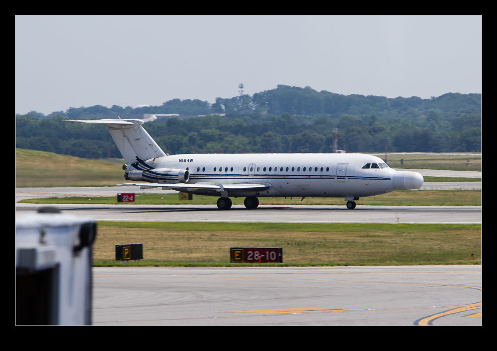 Over recent years I have made many trips that take me through Baltimore Washington International airport or BWI. It is the easiest route for me when heading to Washington DC. One of the nice things about BWI is that Northrop Grumman have a facility there that focuses on radar development. As part of this facility, they have a flight test department that makes use of some interesting aircraft. A few times I have seen one of them on the move while I was in the airport but normally I did not have a camera to hand to catch them. However, one time I did get lucky.
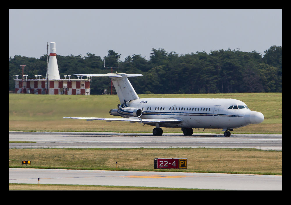
I managed to see their BAC 1-11 taxiing out for departure. This is an aircraft that has received a number of modifications for airborne testing of radar systems. While it is an old airframe and there aren’t many of them in service any more, it obviously still performs the required role well and they continue to operate it. It taxied past the terminal and then departed across in front of us. Since it is a bit dated, the noise levels were apparent even inside the terminal. However, it was fun to see it in action. A recent trip also spotted a smokey trail on approach. Sure enough, it was back. Sadly, no camera to hand that time!
 As we drove along the south side of Maui, we passed through a small settlement. At the side of the road was an old London cab. This was of the vintage of Austin built cabs where there was an open space beside the driver where trunks could be stored. These are a rarity anywhere but to find one so far from London was a surprise. I guess you can always get a London cab if you need one!

 The trip to O’Hare for the arrival of the United 787 meant I had a bit of time to shoot some other aircraft while I was there. I had started out at the arrival end of 28 for the 787 to show up. When we changed rapidly to 10, I was now on a good side of the field for some of the departures.
 Departures at this end can be a good selection. Some will turn towards you and give a nice topside view. Others head out straight or turn away so you are always wondering whether this one will be worthwhile. I wasn’t out for a long time so this was just a chance to see what would come out before heading home. A 747 freighter is a welcome addition but it, sadly, turned away. Even so, it still looks cool. A few gave me a better view. I grabbed some shots and then headed home.
 The drive along Tioga Pass Road is an impressive one with plenty of dramatic scenery around you. As you get to Olmsted Point, your initial view is towards Yosemite Valley. However, if you turn around, you are looking towards Tenaya Lake. This was the next stop on my journey. Looking at the lake from Olmsted Point, it was hard to believe it was real. You are very high along this pass, often above 9,000′, and the sky is a darker blue at that height. Also, the water is clearer since it is either straight from the sky or from snow melt. Consequently, the blues are intense.
 The lake looks like something that someone would create as a made up lake. It is very striking. It isn’t alone either. As you drive further towards the descent to Mono Lake, there are a number of lakes that have been created with dams and they all are pretty impressive. I don’t know how they look on an overcast day but in the sun they look great.