Tag Archives: travel

Shooting the Tight Shots

One camera was set up for the eclipse with the 500mm and the 1.4x teleconvertor.  This was the one I was aiming to get the detail shots with.  I had a solar filter mounted on the lens and had experimented a little with exposures in the days before the eclipse.  A few trial shots showed that the exposures were not too bad and I bracketed everything anyway to be on the safe side.  This set up was very sensitive to the progression of the sun across the sky so, I had to regularly reset the location.  I wished I had a different head on the tripod but the ball head was okay, just a touch sensitive to adjust.  A cable release meant I could stand and watch while triggering the camera without having to be distracted.

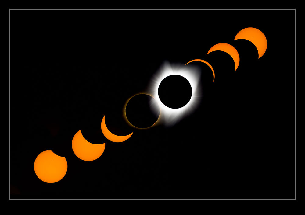
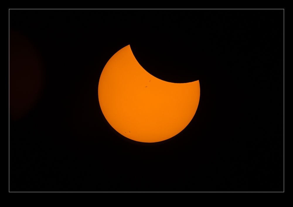
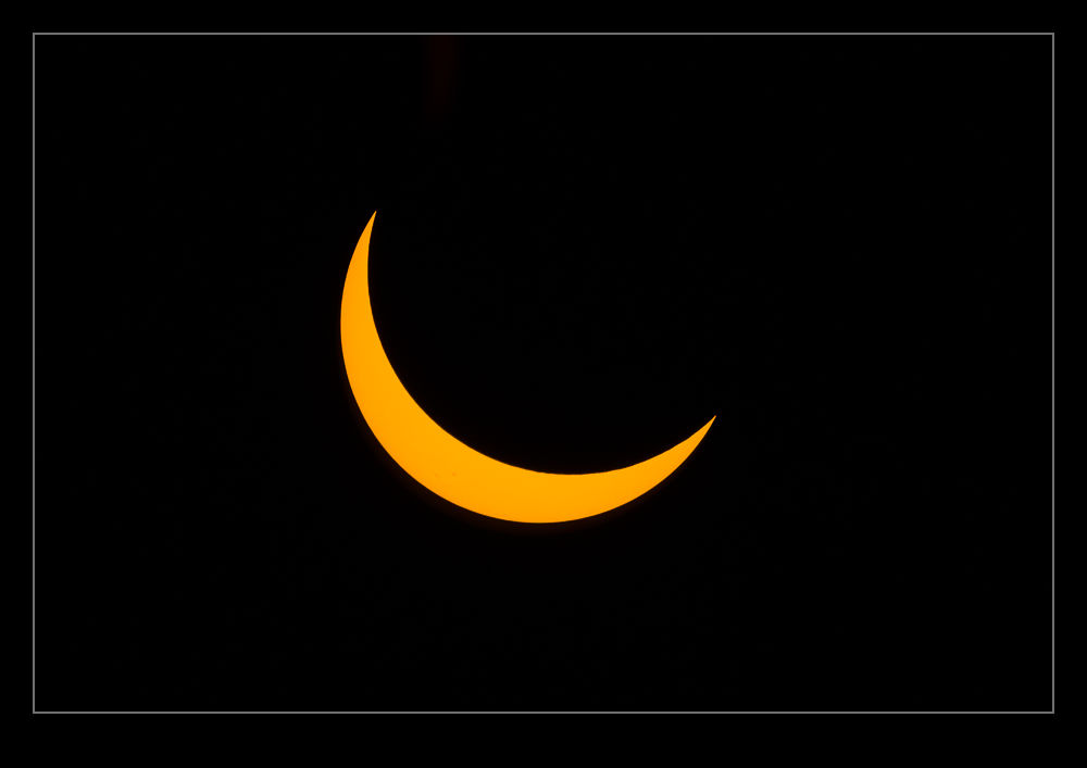
From first contact to totality took over an hour.  At times, it seemed to be moving quickly and at others you felt like it hadn’t moved at all or you even imagined it had retreated.  Of course it hadn’t, but you could imagine all sorts of things while waiting.

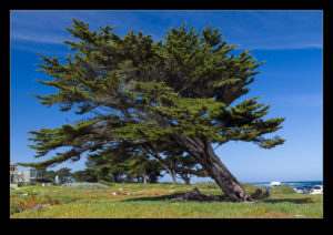
As the level of obscuration increased, it was interesting to see how little some things changed.  Indeed, even when the sun was almost totally gone, the ambient light levels were actually very high.  There was something about the quality of the light that was different though.  We didn’t have a lot of wildlife nearby so some of the things that we had heard about in advance didn’t affect us.  (The mosquitoes certainly were happy judging by the number of bites on my legs!)  As totality approached, we did see a bunch of vultures flying high above us and I wondered what they were about to do when they found themselves in the dark at altitude.  The drop in light levels was rapid and staring around as it happened was very weird.

When totality hit, the last hint of the sun disappeared through our glasses and we took them off.  The view that greeted us is something I shall never forget.  The images are a great reminder but I had seen shots of previous eclipses plenty of times.  Seeing it in person was a rare time when the word awesome truly deserved to be used.  I looked up at the corona and was overwhelmed.  It was stunning.  I felt like it couldn’t be real – like someone had created a CGI effect in front of me.  I can’t imagine what the effect on people was in centuries past.  Since you can’t look at the sun directly and the light doesn’t change too much until the last minute, this would come as a hell of a shock to someone unprepared.  The corona that is left would make you think something apocalyptic was happening.  Knowing it was coming, I was unprepared.  They must have freaked out!

The light on the horizon meant you could still make things out.  It wasn’t totally dark which is what I had anticipated.  I also think some of the high-level cloud was making the corona look a little diffuse.  For a couple of minutes we just stared.  I remembered to take the filter off the long lens but forgot about it on the time lapse camera initially.  I also didn’t change the exposure on that camera even then although more on that another time.  After just over two minutes, the sun peeked back out and everyone cheered for some reason we probably couldn’t explain afterwards.  The light levels rapidly came back up and suddenly it was over.  Sure, there was another hour or so as the transit completed but somehow it was done.  We weren’t in a hurry but people around us started to pack up and leave and, in due course so did we.  As we got to the car, we took one more look through the glasses at the still partially obscured sun and then we started the trek home.

Planning for the Eclipse

A couple of years ago I started thinking about the total solar eclipse.  We were living in California at the time and I had not long before been to an aviation shoot in Madras Oregon.  Madras was almost directly on the centerline of the path of totality so I thought about booking a hotel.  However, I didn’t do it then and time rolled on.  This year we moved to Washington so now Madras was a bit closer – just over five hours away if traffic is flowing freely.

As things got closer, it was time for a more thoughtful approach to what might be involved and this is where Nancy played the leading role.  She was not particularly interested in the eclipse but she knew I was.  Indeed, at one point in the run up she actually asked me if I would prefer to make the trip alone.  I can tell you that, having witnessed everything, she is really glad I didn’t want that!  Salem was the closest place with a good position for the totality.  Situated on I-5 south of Portland, that also meant a lot of other people were going to be going there so that was a non-starter.  Madras is further east which adds a bit to the drive but we focused on that.

We decided to stay in Portland the night before and set out early.  Plenty of people had been flooding in over the previous few days but, no doubt, others would be doing the same as us.  We also chose not to go to Madras itself but to go to Warm Springs just north of Madras.  This is a Native American reservation and they were welcoming people to the baseball fields to watch the eclipse.  The area is very dry so the chances of cloud obscuring things were a lot lower than closer to the coast.  To get there should take just under two hours from our hotel near Portland’s airport.  We decided to leave at 3am to give ourselves plenty of margin.

We did have a Plan B.  While there was a lot of time in the schedule for traffic, if it got really bad, we might just find ourselves on the highway when the eclipse happened.  As long as we got south of Mt Hood, we would be in the path of totality and, if you looked at the charts for timing, you didn’t have to get too far in to have a reasonably long period of totality.  We packed plenty of food and water and assumed, if it was totally congested, we would be with a huge bunch of people on the road and would enjoy it all together.

Getting up just after 2am, we checked the traffic reports online.  Everything was currently clear.  Good news but not necessarily to be relied on to last.  If we were leaving then, how many others were doing the same?  We put our stuff in the car and off we went.  The roads were pretty open and, as we got onto route 26, we were in a steady stream of cars but nothing that would slow you down.  We headed off into the wilderness.  This is a trip that takes you through some great scenery – if it is light.  Instead, we were out in the pitch black.  The stars around us were amazing to see since there was no light pollution if you weren’t looking ahead in the path of the headlights.

The traffic never materialized.  We got to Warm Springs in an hour and fifty minutes, arriving at the parking area fifteen minutes before it was due to open.  We met the nice people looking after things and they informed us we were the first to arrive and to park at the end of the row (which was hard to see in the pitch dark).  We parked up and had a few hours to kill so set the seats in the car up as a sofa and took it easy.  Nancy couldn’t sleep but I dozed off a few times.  Meanwhile, more cars arrived and people started milling around as it gradually got lighter.

Once the sun was up, we went off to look around the town and stretch our legs.  Then we set up our spot for the viewing.  I had brought two main cameras.  One was the longest lens combination I could get and the other had the 100-400 on it which I was planning to use for a time lapse.  I had bought solar filters for both a while back and B&H had shipped them with loads of viewing glasses.  We had shared some with friends already but we carried loads of spares in case anyone needed some.  No-one did though.  Everyone around us was well prepared so our spares stayed in the bag.  Meanwhile, I set the time lapse camera at an angle to see if I would track the path of the sun across the frame.  (I got this wrong as I did not have a steep enough angle.  I tweaked it a couple of times but it wasn’t ideal.  It worked but was a bit wonky!)

Lastly, I opened up the Solar Eclipse Tracker app on my phone which provided an audible guide to what was coming up and we got ready.  The skies were pretty clear initially with a hint of wildfire smoke in the distance.  As the time got closer, some high-level cloud did come in but nothing too significant.  Then it all started.  More to come…

Capilano Suspension Bridge

The arrival of some family members in Vancouver as part of a vacation gave us a reason to make a day trip up to the city.  It is a pretty easy run to get there so we were pleased to head up.  Since the visitors were on vacation, they were keen to explore different things so we decided to head across the Lions Gate Bridge and visit the suspension bridge at Capilano.  This was not something I had been aware of before we planned this.

The bridge has apparently been there for many years.  It is suspended across a deep valley with a river running through the bottom.  It is a very popular attraction and, while we headed there in the morning, we were certainly not alone.  The people that own the bridge have expanded the facilities to include a number of other attractions and these will get their own posts in the coming days.  However, this is just about the bridge.  As it covers quite a distance, the bridge has quite a drop between the ends and the middle.  This makes each end of it quite steep.  Combine that with the number of people crossing, the desire everyone has to look around/get some pictures, and the amount it moves around which unsettles the first-time user and it takes a while to get across.  It is interesting to see that the return journey is a bit quicker!

Being on the bridge gives you one perspective.  Looking down into the valley below is a different point of view.  At various other times, you get a chance to check the bridge out from a distance (when you see how long it is and how many people are on it at any one time) when it also seems rather dwarfed by the surroundings.  You even get to walk underneath it at one point and then it has a very different feel.  If you are spending any time in Vancouver, I do suggest you head to North Vancouver and check the bridge and its associated attractions out.

Fort Ward

Our Bainbridge trip included a bonus element.  I had been advised how busy the ferries could be on nice summer weekends so we headed out early anticipating some long lines to get on the boat.  We got to the terminal about an hour ahead of when we were planning to sail, bought our ticket, drove straight on to a boat and it sailed a minute later!  This was a pleasant surprise.  However, it did mean we were on the island a lot earlier than our planned first stop was open.  We needed to kill some time.

Nancy did a quick search and came across a place called Fort Ward.  We put that in the GPS and headed off.  Fort Ward is an area of the coastline that used to be part of the protection of the approaches to Bremerton naval shipyards.  It was given up by the military a long time ago and now sections of it are rather nice housing and more of it are a state park.  In the early morning, walking along the shore through the park was a very pleasant way to spend some time.

Mount Shasta

The move from the Bay Area to the Seattle area involved a two day drive.  The first part of the drive north is pretty flat but, as you get further north, you get into the southern end of the Cascades Range.  The interstate runs around the south and west of Mount Shasta.  You first see it a long time before you are anywhere near close to it.  These large mountains are not easy to miss provided it is a clear day and the weather was lovely on this occasion.

We pulled off the road briefly at a viewing location.  We were still some distance from the mountain and the view was not unimpeded but I guess this was a better spot than was available further up.  The mountain had plenty of snow on it.  As you looked closer, you could see wisps of cloud above the surface.  I couldn’t tell whether they were actual clouds or snow that was being whipped up by wind as we were too far away.  It took a long time to go by the mountain.  We came up the west side but for a long time it just was there.  Eventually, it was behind us and we continued on to our overnight stop.

More Pretty Coastline Than You Know What to Do With

Our trip down the coast included some driving down the Pacific Coast Highway. This is undoubtedly a gorgeous place to be. Each turn in the coast brings with it another lovely view of rugged cliffs and crashing waves. Add some sun and it really is wonderful. There is little point in saying much more. Instead, here are a few shots to show just how great it is.

Into the Heart of the World

The biggest thing that made me want to go to Big Island was volcanoes.  I have seen plenty of photos and video of volcanic activity but I have never seen it for real.  I wanted to try and experience the awesome power welling up from the heart of the earth.  Awesome is a word that gets pretty free use but I think when it comes to the violence that the layer of energy just below the crust of the earth can produce, awesome is a word that is entirely justified.

The south end of Big Island is the one that is most active volcanically.  Mauna Loa and Mauna Kea are both sitting quietly at the moment but neither of them is considered done.  Mauna Loa has erupted relatively recently.  However, the one that is playing at the moment is Kilauea.  It has been busy erupting for a long time now.  We checked it out by helicopter – the most easygoing way to see things.  We took in two locations of activity.

The first was an open route to the inside of the planet.  It has been active for a long time and has a visitor center.  Apparently, you used to be able to walk close to the edge of the hole as a tourist.  A parking lot is still visible.  However, a violent outburst a few years ago suggested that this location was no longer safe.  Now the visitor’s center is as far as you can go.  There is a circular hole in the larger crater in which the lava bubbles.  The level rises and falls daily and often will come over the lip into the larger crater.  While we were over it things were a bit below the lip but you could still see the heat just below the surface of the lava.  Because the air cools the lava quickly, you rarely see the molten lava is it is usually under a crust.  Still very hot, but not liquid.

We then headed off to another area of activity.  Here there was a rip in the surface from which gases were billowing.  As you looked through the various holes, you could see into the heart of things and the glow from the lava was impressive.  The color was intense and you could sense the heat within.  As the lava emerged from various fissures in the surface, it would cool to make a new crust.  A metallic looking surface would appear.  Occasionally, the lava would bubble forward and, oh so briefly, there would be a red glow on the surface.  Then it would cool and add a bit more to the metallic surface.

Big Island was a constant stream of references to the incredible forces that had formed the island.  The lava fields covered much of the island.  Even on the beaches, you had to be cautious of the lava chunks on the sand.  My delicate feet did not like the lava.  However, nothing could match the raw power that was on display at the volcanoes.  I was certainly not disappointed having focused so much on them in planning the trip.  Nature is amazingly powerful.

The Secret Beach

Being lucky is so cool.  I don’t know how many excellent opportunities I have missed without realizing it (that’s the benefit of not realizing it), but I have been fortunate to stumble into some good stuff.  We were driving down towards Hilo when we came to an overlook above a bay.  We pulled over and walked up to the edge to see a great view down into a lovely looking bay.  The waves were crashing in from the ocean and the place looked cool.  We were so close to moving on after a few minutes.

Just before we turned to go, we saw a couple of people down on a headland in the bay.  We weren’t in a hurry so we figured we would head down the trail and see what was there.  The area was butted up against a botanic garden which we weren’t planning on visiting so we knew we wouldn’t go far.  As we got to the bottom of the trail, we came to an entrance to the garden with a security guard sitting watch over who came through.  Then we saw a small side track alongside the fence heading to the water.  A short excursion brought us to a beach.  The waves were crashing up on the shore by our feet and everything was covered over with a dense canopy of trees.  A little climb took me out onto a spur of rock with the waves crashing either side.  A rocky cliff face was on one side and the waves were striking it violently.

There was a small blowhole in the rock near where I stood.  As the waves came in just right, the water would fire out of the hole.  Other times nothing would happen or there would be a small gurgle.  I talked to a couple of guys out there who obviously knew the place well.  They pointed out how far out you could go without getting completely drenched by the waves.  More importantly, it looked like the sort of place that you could get caught out by a wave easily.  If you went into the water, I suspect it could have ended badly.

Forget that though.  The place was gorgeous.  When the guys left, we were the only ones there.  The waves were pounding the shore, the scenery was stunning and you felt like you were the only person in the world who knew it was there.  It was hard to break away.  We stood there for ages.  Sometimes the waves would come that bit further up the beach than normal and they would wash over my feet.  No point in objecting.  Just stand there and enjoy it.  Of course, we had to leave eventually.  Those visiting the botanic garden had a promontory a short distance away but they were really not in a good position to enjoy the experience because they were on one of the nicer parts.  We met a couple coming down the trail as we left.  They looked ready to turn back and had not seen where we had gone.  We made sure to explain where they needed to go.  I hope they liked it.

Crescent Lake

B11I7854.jpgThe drive to the rain forest from Port Angeles took us alongside Crescent Lake.  I suspect I don’t need to tell you roughly what shape the lake is but, if you don’t know, check it out on a map!  It was a pretty overcast morning when we drove by but this provided some soft lighting on the surrounding hills and also gave some interesting clouds to sit in some of the valleys and near the hill tops.

B11I7827.jpgThere were plenty of pull off locations along the road that skirts the south side of the lake.  It appears that the north side is pretty inaccessible by vehicle when looking at the maps of the area.  Only when you get to the west end of the lake do you start to see properties on the other side so I guess the road access up there does not go too far.  The water in the lake was very calm and the whole thing had a very ethereal feel about it.

B11I7835.jpg

Cottonwood and Truckee at Night

AE7I4348.jpgWe headed back in to Truckee one evening for dinner.  We were eating at a restaurant called Cottonwood.  It is only a short distance from the center of the town but it is up on a hillside so has a great view down to the main street.  The sun went down while we were having dinner which was taken out on the terrace.  The restaurant has a cool sign that illuminates when it gets dark.  Meanwhile, the town lights up beneath you.  It was a bit chilly – they didn’t turn on the outdoor heaters – but you could have a blanket if you wanted.  We did fine without but, if it had got much colder, I might have taken them up on the offer.

AE7I4346.jpg